The Atlas of 1200 is a free reference work describing every realm, ruler, lord, town, church land and frontier of the known world as it stood at first light on 1 January 1200, from Iceland to Japan.
Each entry gives who held what and how they came to hold it, what it was worth and what threatened it, what the year ahead brought and on what it depended, where the sources disagree, and the primary sources and studies behind it. It is written one morning at a time: anything that happened after sunrise on 1 January 1200 is kept apart, with its date.
Who ruled the world in 1200 The primary sources Open the full map
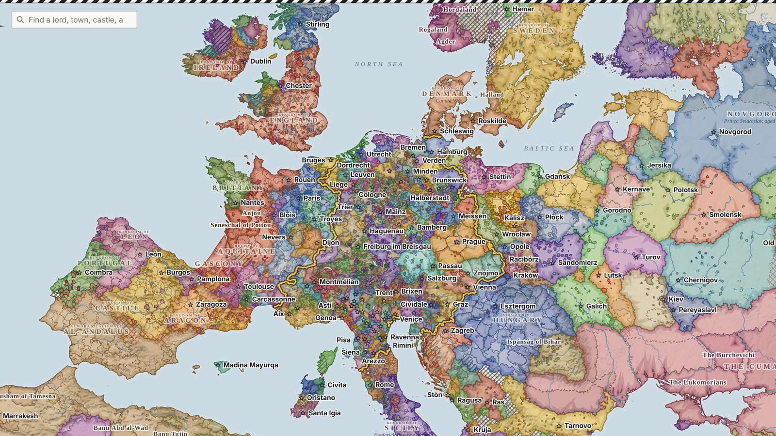
The world by region
- France and Iberia25 realms
Contested, Angevin lands, Castile, Aragon, León and more
- The British Isles20 realms
England, Scotland, Lordship of Ireland, Connacht, Argyll and more
- The Rhineland, the Low Countries and the Swiss Lands32 realms
Empire, Staufen, Welf, Thuringia, Holstein and more
- Northern Italy50 realms
Patriarchate of Aquileia, Smaller communes, Margraviate of Istria, Trent, Milan and more
- Eastern Germany, Bohemia and Austria15 realms
Kingdom of Bohemia (Ottokar I), Pomerania, Bavaria, Moravia, Styria and more
- Southern Italy and the Islands11 realms
Sicily, Papal State, Corsica, Cagliari, Torres and more
- Scandinavia8 realms
Sami, Norway (Sverre), Sweden, Finland, Denmark and more
- Iceland and the Faroes8 realms
Iceland, Ásbirningar, Svínfellingar, Haukdælir, Vatnsfirðingar and more
- Poland, Hungary and the Adriatic15 realms
Hungary, The Prussians, Masovia and Kuyavia, Transylvania (voivode Legforus), Sandomierz (Leszek the White) and more
- The Balkans and Byzantium9 realms
Byzantium, Bulgaria, Serbia, Zeta, Ivanko and more
- The Baltic and Rus'24 realms
Novgorod, The Cumans, Volga Bulgaria, Vladimir-Suzdal, Chernigov (the Olgovichi) and more
- The Latin East and the Ayyubids18 realms
Egypt, Ayyubid Jazira, Damascus, Aleppo, Mosul and more
- Anatolia and the Caucasus12 realms
Sultanate of Rum, Eldiguzids, Alans and mountain peoples, Georgia, Ahlat and more
- Persia and the Eastern Islamic World28 realms
Ghurids, Khwarazm, Kangli and Qipchaq, Turkmen, Qara Khitai and more
- The Maghreb and the Sahara13 realms
Sanhaja of the Sahara, Veiled Berbers (Tuareg), Tubu, Almohads, The oases and more
- West Africa: the Sudan and Guinea21 realms
Kanem, Manden, Yoruba towns, Ghana, Sao and more
- Nubia and the Horn of Africa11 realms
Somali clans, Makuria, Beja, Alodia, Afar and more
- Arabia12 realms
The Bedouin, Mahra, Ayyubid Yemen, Zaydi imamate, Sulaymanis and more
- The Swahili Coast and the Gold Country8 realms
Plateau chiefdoms, Toutswe, K2 kingdom (Mapungubwe), Sofala, Swahili towns and more
- The Tarim, the Uyghurs and Xia5 realms
Great Xia, Self-governing peoples, Tarim oases, Qarluq, Qocho
- Mongolia and the Steppe13 realms
Self-governing peoples, The Naiman, Unaligned Mongol clans, The Yenisei Kyrgyz, Kereyit and more
- North China and Manchuria4 realms
Jin empire, Amur and Ussuri peoples, Self-governing peoples, Khitan and Xi
- South China3 realms
Southern Song, Chiefs of the south-west, Peoples of the south
- Northern India16 realms
Self-governing peoples, Senas of Bengal, Paramaras of Malwa, Independent Rajput houses, Kalachuris and more
- Southern India and Sri Lanka12 realms
Yadava kingdom (Devagiri), Self-governing peoples, Hoysala kingdom, Chola empire, Kakatiya kingdom (Orugallu) and more
- Tibet and the Himalaya5 realms
Self-governing peoples, Tibet (centre), Guge and Maryul, Khasa kingdom, Nepal valley
- Korea and Japan8 realms
Goryeo, Kyoto court, Kamakura regime, Ezo (Hokkaido, Sakhalin tip, south Kurils), Temple powers (west) and more
- Mainland Southeast Asia14 realms
Self-governing peoples, Khmer empire, Kingdom of Pagan, Dali, Shan and Kachin valley lordships and more
- Island Southeast Asia14 realms
Peoples, Malay ports, Palembang, Malayu, Kediri and more
On the map today
- 434 realms
- 2,781 lords and officers
- 5,473 towns, ports and sites
- 832 church lands and religious houses
- 1,634 provinces, peoples and free lands
- 307 primary sources in the library
How every entry is made
One morning, one date
Every entry describes 1 January 1200. Later events are listed under "what the year holds" with their dates, what they depended on and what would have stopped them.
Sources on every page
Each entry ends with the chronicles, registers and studies it rests on, linked where they are online, and each realm carries the primary sources that cover it.
Honest about gaps
Where the record is thin, the entry says so and rates its confidence. Where the sources disagree, the entry gives both readings. Numbers appear only where a source gives them.
One map, one dataset
The Atlas and the map are one body of research: every realm, lord, town and church land on the map has its entry here, and every entry has its place on the map.
Questions people ask
What is the Atlas of 1200?
The Atlas of 1200 is a free reference work describing every realm, ruler, lord, town, church land and frontier of the known world as it stood at first light on 1 January 1200, from Iceland to Japan. It is published by OMNIA at omniamap.com. Each entry gives who held what, how they came to hold it, what it was worth, what threatened it, what the year ahead brought, where the sources disagree and which primary sources and studies the entry rests on.
Why 1 January 1200 and not the year 1200?
Because a year is not a moment. On 1 January 1200 the treaty of Le Goulet had not been signed, John of England had not married Isabella of Angouleme, Conrad of Wittelsbach still held Mainz, Bishop Albert had not yet sailed for the Duna, and the interdict on France over Ingeborg was only arriving. The Atlas describes one morning and keeps everything that happened later in a dated list of what the year held, with the conditions each event depended on.
Who ruled England, France and the Empire on 1 January 1200?
England: King John, crowned 27 May 1199. France: Philip II Augustus. The Empire: disputed between Philip of Swabia and Otto IV, with Pope Innocent III weighing the two. The full table of every realm and its ruler is on the Rulers page.
How many realms were there in 1200?
The Atlas map draws 438 realms, from kingdoms and caliphates to communes, kindreds and self-governing peoples, with 2,781 lords and officers, 5,473 towns, ports and sites, 832 church lands and religious houses and 1,634 provinces, peoples and free lands. The count depends on what one calls a realm; the Atlas says on each page what kind of power it describes.
What are the main primary sources for the year 1200?
For Western Europe, Roger of Howden, Ralph of Coggeshall and Rigord, the English pipe and charter rolls, and the registers of Pope Innocent III. For the Empire, the Royal Chronicle of Cologne, Arnold of Lubeck and Otto of St Blasien. For Byzantium, Niketas Choniates. For the Islamic world, Ibn al-Athir, Abd al-Latif al-Baghdadi and Ibn Jubayr. For China, the Jin shi and Song shi. For Japan, the Azuma kagami and the diary Gyokuyo. For the Mongols, the Secret History. The sources library lists them all, with editions, translations and where to read them online.
What was happening in the world at the start of 1200?
In the west, John and Philip Augustus were moving towards the settlement of Le Goulet, the Fourth Crusade was being preached and Innocent III was pressing France over Ingeborg. In Iberia, Castile was finishing the conquest of Alava while Navarre's king sat at the Almohad court. In Germany two kings fought for the crown. In the east, Alexios III held Constantinople against Kaloyan's Bulgaria, al-Adil was taking the Ayyubid sultanate from his great-nephew, Tekish ruled Khwarazm and the Ghurid brothers held Ghazni and Delhi. In the steppe, Temujin was fighting his way to the mastery of the Mongols. The Jin and Song were at peace, Choe Chung-heon ruled Goryeo behind the throne, and at Kamakura Yoritomo's heir Yoriie was being hemmed in by his father's men.
How accurate is the Atlas, and can I correct it?
Every entry carries a confidence rating for its ruler and says plainly where the sources are thin or disagree. Numbers of troops and money are given only where a source gives them. Corrections are welcome on the OMNIA Discord, and each page shows when it was last revised.
Is the Atlas free to use, and how should I cite it?
Yes. Read it, link to it and quote it with attribution. Cite it as: OMNIA, The Atlas of 1200, omniamap.com/1200, with the page's URL and revision date.